There’s no shortage of ways to find peaceful escapes in order to explore the outdoors in the City of Oaks. Use any of the Raleigh area’s 180 miles of green ways or numerous other miles of trails traversing through parks.
You’ll find runners getting in workouts, cyclists out for leisurely rides, parents pushing strollers and people of all ages soaking up the fresh air. Below are some of our favourite spots to seek out solitude and sun.
White Oak Creek and Black Creek Greenways
A newly-completed section of greenway, opened in March of 2019, marked a big occasion for outdoor enthusiasts and residents of Cary and Apex.
A pivotal section of the White Oak Creek Greenway—made up of nearly 1.5 miles of winding boardwalk and a half-mile of pavement—has finished construction, meaning the trail now stretches approximately 7.5 miles in total from east to west, beginning at Fred G. Bond Metro Park (where a perfect field for picnics and plenty of boat rentals await) and ultimately connecting to the American Tobacco Trail. Combined with the Black Creek Greenway (begins near Lake Crabtree County Park/William B. Umstead State Park and ends at Bond Park), the two greenways make up 15 miles of continuous path to be used by runners, joggers, cyclists and more.
Mostly flat with a few short and steep hills, the Black Creek Greenway—officially beginning at the Old Reedy Creek Rd. trailhead where bathrooms and more than 80 parking spaces are available—travels north to south, quietly passing by neighborhoods, schools and shopping areas. The White Oak Creek Greenway, also mostly flat, passes through more rural areas of Cary and Apex, using lots of boardwalks to cross over marshes and wetlands, before connecting to a gorgeous, unpaved portion of the heavily-trafficked American Tobacco Trail.
Together, these two greenways now make up a portion of the longest complete metro stretch of the East Coast Greenway (an in-development route of trails and greenways that will ultimately stretch 3,000 miles up and down the East Coast), plus provide connections to travel from one side of Wake County to the other (and beyond!).
Total mileage: 15 miles total, from William B. Umstead State Park to the American Tobacco Trail (more if you continue in either direction)
Best for: Families, children, pets on leashes, runners, slow bike rides
The Neuse River Greenway Trail—a 27.5-mile paved, uninterrupted greenway that stretches from Falls Lake in North Raleigh to the Wake County line in southeast Raleigh—is a year-round haven for outdoor recreation. With views of historical sites as well as winding boardwalk areas and suspension bridges crossing over wetlands, the trail is open to joggers, walkers, runners, cyclists, roller-bladers and others. Many consider the Neuse River Greenway Trail to be the gem of the 100-plus-mile Capital Area Greenway System.
There’s no shortage of starting and stopping points along the trail, but one easy access point for visitors is to begin at the Falls Lake trailhead, where The Bike Guy—a full-service bike shop with rental bikes available—sits right beside the parking lot. Heading south, you’ll find lots of families, children and more foot traffic in general in the first few miles before the path clears quite a bit. From the trailhead, it’s approximately eight miles of flat terrain until you reach Horseshoe Farm Nature Preserve, a 146-acre jewel of open space surrounded by some of the most scenic greenway miles in the entire area (a parking lot here is also a good option for starting a run or ride).
The southern portion of the trail travels through more wetlands and secluded areas and is less trafficked, but equally scenic. A good place to start is Anderson Point Park, which has plenty of parking, bathrooms and water fountains (note: heading south from this point, you may not find another place to stop for water). From here, you’ll begin to find white picket fences running along wide-open land and a mix of shaded and sunny portions of the trail. If you time it right, you’ll find acres upon acres of sunflower fields in full bloom in early or mid-July. It’s approximately 11 miles from Anderson Point Park to the end of the trail, with just one or two short and small hills to compete with.
Total mileage: 55+ miles if you’re up for a full out-and-back, but lots of starting and stopping points are available. If you’re really feeling up for a challenge, check out Oak City Cycling Project’s Neuse Deuce Challenge — a one-day, 200km (129 miles) route mostly completed along the Neuse River Greenway Trail.
Best for: Long runs and rides; families; solitude
Beginning at the North Carolina Museum of Art (where parking and admission to the museum are free) and ending in downtown Raleigh, this 5.9-mile, paved trail winds through the museum’s beautiful 164-acre park, passes behind Meredith College, cuts through the main campus of North Carolina State University, zips by Pullen Park and finishes in the heart of the city just outside of the Duke Energy Center for the Performing Arts (where coffee and treats from spots like Bittersweet, Boulted Bread and lucettegrace await nearby).
The trail can be done in reverse, of course, and bike racks are on hand at the museum so you can lock up for a bit while you explore the galleries (highly recommended) or set up for a lunch break in the park outside. Relatively flat, the Art to Heart Trail does have a couple standout hills on the edge of the museum park. If coming from downtown, the final hill into the museum park is a short and steep 0.2-mile climb with an eight-percent average gradient. According to Strava—a popular GPS tracking app for athletes—cyclists have made more than 20,000 attempts at this hill since 2011 (the fastest ever recorded time to the top is 29 seconds; mere mortals will take closer to 90 seconds).
For those interested in a more leisurely stroll, you really never have to leave the museum park. A one-mile paved trail, the Blue Loop, is open to walkers, skaters, joggers and cyclists—families with young children, strollers and dogs are a common sight along this path that traverses past some of the park’s major art pieces. An additional mile of unpaved trails, not open to cyclists, is a perfect way to find some solitude amongst nature. View a map of the Art to Heart Trail here.
Total mileage: 5.9 miles if you complete the trail in one direction
Best for: Leisurely strolls; running; bike rides; families; art lovers; college campus views; picnics
Located near North Carolina State University, Lake Johnson Park is a popular spot for students and professionals to get some exercise—a paved, three-mile greenway loop, plus two miles of unpaved trails, draws lots of joggers and walkers (and dogs, too!). The paved section, east of the boathouse, packs some punchy hills and tends to draw a bigger crowd. The unpaved section, west of the boathouse, is flatter but great for hikers looking for a quieter adventure. Bikes are allowed on both sections of the mostly-shaded trails but can’t complete the full loop on the unpaved side because of an environmentally-sensitive area (runners and hikers are still able to complete the loop).
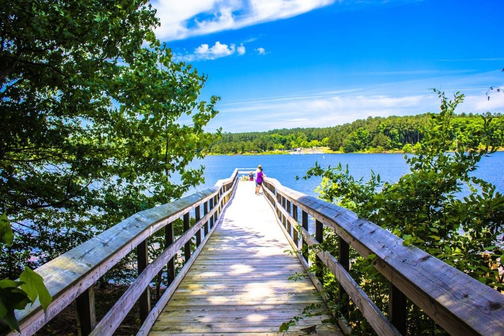
The most recognizable feature of the park is the 700-foot-long boardwalk that cuts directly across the center of the lake, often busy with people dangling fishing poles over the side or watching kayakers and pedal boats circle the 150-acre body of water.
On the northern end of the lake, the east loop of the trail can connect with the Walnut Creek Greenway which gives you access to North Carolina State University’s Centennial Campus (two miles away), Dorothea Dix Park (3.5 miles), downtown Raleigh (five miles) and the Neuse River Greenway Trail (13 miles)—lots of great options for more exploring!
Total mileage: Five miles if you complete both loops, and more if you venture outside the park
Best for: Leisurely walks; dogs; running
N.C.’s most-visited state park, William B. Umstead State Park remains a peaceful getaway thanks to its sheer size—more than 5,000 acres of forest, trails and lakes sit on the edge of Raleigh, Cary and Morrisville. With 13 miles of multi-use trails that follow a series of rolling hills (perfect for horseback riding, jogging and cycling) and 22 miles of dedicated hiking trails, this is a must-hit destination for outdoor enthusiasts.
Cyclists are drawn to Umstead for the gravel riding—the multi-use paths are a mixture of hard-packed dirt surfaces along with some fairly rocky gravel sections among the handful of trails that are open to bikes. No paved roads will be found here, and that’s part of the appeal. You’ll see all types of rides tackling the terrain inside Umstead, from full-suspension mountain bikes to trendy, new gravel bikes (road bikes with bigger tires, in simple terms). The important thing is you’ll want tires that are, at minimum, 28mm in width (bigger will be better) to comfortably handle the bumpy surface.
One favorite way to take advantage of the multi-use trails for both cyclists and runners is to park your vehicle at the Old Reedy Creek Rd. trailhead (plenty of parking spots, bathrooms, water fountains and bike repair tools are on hand here), head just a couple hundred yards up the short hill to the park entrance and follow the Reedy Creek Trail on a straight shot until you hit the far end of the park—that’s a total of five miles one way. From there, either head back the way you came or turn left to tackle the South and North Turkey Creek Trails (warning: brutally steep in a couple sections!) which will add an additional six miles or so to your route before heading back to your starting point (take a look at the full map here).
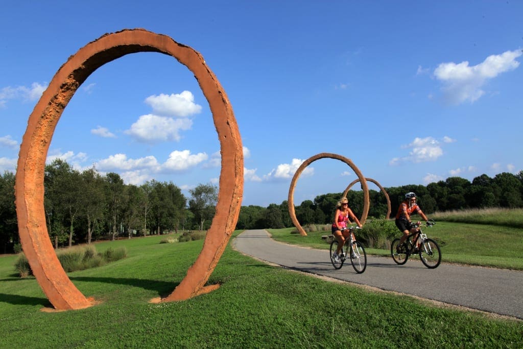
Hikers and singletrack runners have plenty of options, too, starting with Sycamore Trail, a moderately easy loop trail with plenty of elevation changes and lots of shade that runs beside Sycamore Creek for a total of 7.2 miles and has the option to connect to many other trails along the way (hop onto the Graylyn multi-use trail to find the incredible piece of chainsaw art pictured in the header of this article).
Total mileage: As much or as little as you like; trails range from one mile to seven miles and can be mixed and matched
Best for: Workouts; trail running; hiking; gravel riding/mountain biking; hills; dogs; families; shade
When the 308-acre property at Dorothea Dix Park was acquired by the City of Raleigh in 2015, it instantly became the largest city park in the City of Oaks—the site blends historic architecture and rich landscapes on the edge of downtown Raleigh (the closest park entrance is about one mile from the Raleigh Convention Center). Named for Dorothea Lynde Dix, an American activist on behalf of people with mental illness, the site spent 150 years as Dorothea Dix Hospital and more recently has been home to the N.C. Department of Health and Human Services. In the future, the City of Raleigh has big plans for a transformative public space.
For now though, massive open fields, tree-lined streets, skyline views and very minimal car traffic make this park an ideal place for all sorts of outdoor activities. There are no real trails here (although the Walnut Creek Greenway does connect along the northern edge of the park), but you can follow the paved roads inside the park to map your own adventure. A loop along the outer edges comes out to a little under three miles total—it’s not uncommon to see some of the area’s fastest runners putting in some tough workouts here on any given day.
Cyclists can rack up the miles here, too—the pavement is a bit bumpy in spots though, which is why our preference is to go off-road and try out the almost-hidden cyclocross course in the back of the park (cyclocross is a winter sport for racing bicycles through dirt, grass, mud and sometimes over obstacles). The curvy, winding dirt course, nearly two miles in length, is best for mountain bikes or other bikes designed to take some bumps (a typical cyclocross bike has no suspension but comes with 33mm wide tires).
Whether you’re running, biking or walking, be sure to leave some time to take in the views—there aren’t many better vantage points to see the Raleigh skyline.
Total mileage: That’s up to you, but a roughly three-mile loop can be done around the outside of the park and a nearly two-mile cyclocross loop can be found in the southwest portion of the park
Best for: Workouts; solitude; skyline views; picnics; easy access to downtown Raleigh
The paved, two-mile trail that loops around Shelley Lake is a favorite for many in the North Raleigh area. Relatively flat, and shade-covered for about half of the loop, the trail provides great views of the lake almost the entire way around (and is a go-to spot for sunset watching).
Because Shelley Lake tends to draw a pretty good crowd (including lots of kids and dogs), it’s better for runners and walkers rather than cyclists, especially at peak times. A couple of open spaces that are great for families to kick a soccer ball around or throw a frisbee, plus bathrooms, water fountains and a fishing pier are also onsite.
Keep your eyes peeled for wildlife—as of spring 2018, it’s reported that multiple blue heron nests and at least one bald eagles’ nest are active!
Total mileage: Two miles
Best for: Leisurely strolls; families; lake views; running
This county park, now with a brand-new name, opened in July of 2010, just two years after the landfill that previously occupied the space ceased operations. North Wake Landfill District Park—as it was called until recently—was the result of transforming the 73-acre site back into a public space filled with greenery and a massive hill that’s perfect for running and biking up and down.
The park is made of 1.8 miles of paved trails, two miles of mountain biking trails, a small mountain biking skills practice area and a 1.4-mile cycling, running and walking lane that circle the main hill. The main attraction, The Top of the Hill Trail, is a short, steep and rocky climb (almost 200 feet of elevation are gained in just under a tenth of a mile), rewarded with a 360-degree view of Wake County that can’t be found anywhere else—on a clear day you’ll be able to see the downtown Raleigh skyline in the distance (nearly 10 miles away!). A second steep hill, slightly smaller and just a stones throw away, makes for a good warmup or practice run.
One of the best things about Green Hills is the connection to the Neuse River Greenway Trail. Starting at the Falls Lake trailhead on the Neuse River Greenway Trail, you get the chance to branch off towards Green Hills just 2.6 miles into your trek—a short, 1.5-mile detour on the Abbotts Creek Greenway takes you straight into the entrance of the county park, giving runners and cyclists a chance to tackle some hills before continuing on their way.
For more information on things to do in Raleigh, North Carolina, click here. Photos courtesy of Visit Raleigh.
To find the best accommodation in Raleigh and worldwide flights, please search via our comparison engine, which scans all the major booking sites.
Click to search for hotels with Agoda